
by Rock Snot
Here are flows for 1/15/2026! Gauge reports show dropping flows in New Mexico and Colorado, but the NM flows are still doing pretty good with the OV/Racecourse at 598 cfs. It’s harder to estimate the Lower Taos Box since the Rio Pueblo de Taos gauge is reporting icing issues, so that puts the LTB probably at most at 598 cfs (the flow reported for TJB gauge). Upstream the Cerro gauge (Razorblade, Upper Taos Box) is trending upward from a low of 157 cfs on Monday to 311 cfs tonight. Up in Colorado, the Wellsville gauge on the Arkansas River (for the Royal Gorge) is reporting 283 cfs (no idea about ice dams or bridges), and for the Shoshone section of the Colorado (in Colorado), the reported flow is 667 cfs. And out west in Utah, in Cataract Canyon of the Colorado, the reported flow at Gypsum Canyon near Hite is 3,740 cfs.
WARNING: when weather is cold enough to allow ice to form in rivers, these rivers can develop ice "bridges" or places where a layer of ice (sometimes thick) is formed across the river. Just because there is a flow doesn't mean there aren't significant (and dangerous) ice obstructions in the river.
NOTE: gauge readings can be distorted when ice is forming in rivers.
Rio Grande
*Rio Grande near Del Norte: NAhttps://dwr.state.co.us/Tools/Stations/RIODELCO?params=DISCHRG
*Ute Mountain (Lobatos Gauge): 302 cfs,https://dwr.state.co.us/Tools/Stations/RIOLOBCO?params=DISCHRG
*Razorblade (Cerro Gauge): 318 cfs,https://waterdata.usgs.gov/monitoring-location/08263500/#parameterCode=00060&period=P7D
*Upper Taos Box (Cerro Gauge): 318 cfs,https://waterdata.usgs.gov/monitoring-location/08263500/#parameterCode=00060&period=P7D
*Middle Taos Box (Cerro Gauge + Red River Gauge below Fish Hatchery, NM): 363 cfs,https://waterdata.usgs.gov/monitoring-location/08263500/#parameterCode=00060&period=P7Dandhttps://waterdata.usgs.gov/monitoring-location/08266820/#parameterCode=00060&period=P7D
*Lower Taos Box (Taos Junction Bridge, NM): at most 598 cfs [note: Rio Pueblo de Taos gauge Below Los Cordovas is not reporting due to ice],https://waterdata.usgs.gov/monitoring-location/08276500/#parameterCode=00060&period=P7Dandhttps://waterdata.usgs.gov/monitoring-location/08276300/#parameterCode=00060&period=P7D
*Orilla Verde (Taos Junction Bridge, NM): 598 cfs,https://waterdata.usgs.gov/monitoring-location/08276500/#parameterCode=00060&period=P7D
*Racecourse (Taos Junction Bridge, NM): 598 cfs,https://waterdata.usgs.gov/monitoring-location/08276500/#parameterCode=00060&period=P7D
*White Rock Canyon (Otowi Bridge, NM): 723 cfs,https://waterdata.usgs.gov/monitoring-location/08313000/#parameterCode=00060&period=P7D
Rio Chama
*Rio Chama (La Puente Gauge): 81 cfs,https://waterdata.usgs.gov/monitoring-location/08284100/#parameterCode=00060&period=P7D
*Rio Chama (below El Vado Gauge): 94 cfs,https://waterdata.usgs.gov/monitoring-location/08285500/#parameterCode=00060&period=P7D
*Rio Chama (above Abiquiu Reservoir): 97 cfs,https://waterdata.usgs.gov/monitoring-location/08286500/#parameterCode=00060&period=P7D
*Rio Chama (below Abiquiu Dam): 96 cfs,https://waterdata.usgs.gov/monitoring-location/08287000/#parameterCode=00060&period=P7D
Red River
*Below Fish Hatchery near Questa, NM: 45 cfs,https://waterdata.usgs.gov/monitoring-location/08266820/#parameterCode=00060&period=P7D
Rio Pueblo de Taos
*Below Los Cordovas, NM: NA (ice),https://waterdata.usgs.gov/monitoring-location/08276300/#parameterCode=00060&period=P7D
Jemez
*Near Jemez, NM: 15 cfs,https://waterdata.usgs.gov/monitoring-location/08324000/#parameterCode=00060&period=P7D
Canadian River
*Near Taylor Springs, NM: 10 cfs [note: gauge reading had been off in the summer]https://waterdata.usgs.gov/monitoring-location/07211500/#parameterCode=00060&period=P7D
Pecos River
*Near Pecos, NM: 31 cfs,https://waterdata.usgs.gov/monitoring-location/08378500/#parameterCode=00060&period=P7D
*Near Anton Chico, NM: 53 cfs,https://waterdata.usgs.gov/monitoring-location/08379500/#parameterCode=00060&period=P7D
*Below Brantley Dam near Carlsbad, NM: 19 cfs,https://waterdata.usgs.gov/monitoring-location/08401500/#parameterCode=00060&period=P7D
Gila River
*Near Gila Hot Springs, NM: 51 cfs,https://waterdata.usgs.gov/monitoring-location/09430030/#parameterCode=00060&period=P7D
*Near Gila, NM: 70 cfs,https://waterdata.usgs.gov/monitoring-location/09430500/#parameterCode=00060&period=P7D
*Near Redrock, NM: 85 cfs,https://waterdata.usgs.gov/monitoring-location/09431500/#parameterCode=00060&period=P7D
San Francisco River
*At Reserve, NM: 2 cfs,https://waterdata.usgs.gov/monitoring-location/09442681/#parameterCode=00060&period=P7D
*Near Glenwood, NM: 22 cfs,https://waterdata.usgs.gov/monitoring-location/09444000/#parameterCode=00060&period=P7D
Arkansas River
*Pine Creek/Numbers/Fractions, CO: At Granite Gauge: NA (ice),https://dwr.state.co.us/Tools/Stations/ARKGRNCO?params=DISCHRG; Below Granite Gauge, main Pine *Creek/Numbers/Fractions gauge: NA,https://waterdata.usgs.gov/monitoring-location/07087050/#dataTypeId=continuous-00060-0&period=P7D
*Browns Canyon (near Nathrop Gauge, CO): NA,https://waterdata.usgs.gov/monitoring-location/07091200/#dataTypeId=continuous-00060-0&period=P7D&showMedian=false
*At Salida, CO: NA (ice),https://dwr.state.co.us/Tools/Stations/ARKSALCO?params=DISCHRG
*Royal Gorge (Wellsville Gauge, CO): 283 cfs,https://www.dwr.state.co.us/Tools/Stations/ARKWELCO?params=DISCHRG
San Juan River
*At Pagosa Springs, CO: 111 cfs,https://waterdata.usgs.gov/monitoring-location/09342500/#dataTypeId=continuous-00060-0&period=P7D&showMedian=false
*At Farmington, NM: 622 cfs,https://waterdata.usgs.gov/monitoring-location/09365000/#parameterCode=00060&period=P7D
Piedra River
*Near Arboles, CO: NA,https://waterdata.usgs.gov/monitoring-location/09349800/#dataTypeId=continuous-00060-0&period=P7D&showMedian=false
Animas River
*Below Silverton, CO: NA (ice),https://waterdata.usgs.gov/monitoring-location/09358000/#dataTypeId=continuous-00060-0&period=P7D&showMedian=false
*At Tall Timber Resort above Tacoma, CO: NA (ice),https://waterdata.usgs.gov/monitoring-location/09359500/#parameterCode=00060&period=P7D
*At Durango, CO: 195 cfs,https://waterdata.usgs.gov/monitoring-location/09361500/#dataTypeId=continuous-00060-0&period=P7D&showMedian=false
*Below Aztec, NM: 255 cfs,https://waterdata.usgs.gov/monitoring-location/09364010/#parameterCode=00060&period=P7D
Gauges Pages:
American Whitewater - Arizona:https://www.americanwhitewater.org/.../state.../state/AZ/
American Whitewater - Colorado:https://www.americanwhitewater.org/.../state.../state/CO/
American Whitewater - Texas:https://www.americanwhitewater.org/.../state.../state/TX/
American Whitewater - Utah:https://www.americanwhitewater.org/.../state.../state/UT/
Stations - Current Conditions - Colorado Department of Natural Resources:https://dwr.state.co.us/tools/stations
USGS Current Conditions for New Mexico: Streamflow: https://waterdata.usgs.gov/nm/nwis/current/?type=flow...
USGS Current Conditions for USGS 07087050 ARKANSAS RIVER BELOW GRANITE, CO:https://waterdata.usgs.gov/usa/nwis/uv?07087050
USGS Current Conditions for USGS 08447300 Pecos Rv at Brotherton Rh nr Pandale, TX:https://waterdata.usgs.gov/nwis/uv?site_no=08447300
USGS Current Conditions for USGS 09380000 COLORADO RIVER AT LEES FERRY, AZ:https://waterdata.usgs.gov/az/nwis/uv?site_no=09380000
More Regional Flows…
Rio Grande (Box Canyon near Creede, CO): 2 cfs
Rio Grande (Wagon Wheel Gap, CO): NA
Rio Grande (Hoodoos Section of Big Bend, TX): 107 cfs
Rio Grande (Mariscal Section of Big Bend, TX): 137 cfs
Pecos River (near Pandale, TX): 56 cfs
(more accurate flows can be found at Poudre Rock Report: http://www.poudrerockreport.com/ and https://www.facebook.com/rockreport)
Clear Creek (near Lawson, CO): 19 cfs
Clear Creek (at Golden, CO): 35 cfs
Colorado River (Gore Canyon, CO): 388 cfs
Colorado River (Pumphouse Section, CO): 388 cfs
Colorado River (Shoshone Section, CO): 667 cfs
Colorado River (Westwater Canyon, UT): 2,170 cfs
Colorado River (Cataract Canyon, UT): 3,740 cfs
Colorado River (Grand Canyon, AZ): about 8,660 cfs - about 12,900 cfs
Green River (near Greendale, UT): 854 cfs
Green River (near Jensen, UT): 1,210 cfs
Conejos River (below Platoro Reservoir, CO): 11 cfs
Dolores River (below McPhee Reservoir, CO): 16 cfs
Gunnison River (Black Canyon, CO): 380 cfs
Gunnison River (Gunnison Gorge, CO): 380 cfs
San Miguel River (near Placerville, CO): 61 cfs
North Fork South Platte (Bailey Canyon, CO): NA
North Fork South Platte (Foxton Run, CO): NA
South Platte (Chutes Run below Deckers, CO): 127 cfs [Note: gauge data from secondary sources, gauge page says reliability is unknown.]
South Platte (Waterton Canyon, CO): 217 cfs
Yampa River (at Steamboat Springs, CO): NA (ice)
Yampa River (above Elkhead Creek near Hayden, CO): NA (ice)
Salt River (Day Section below U.S. 60 Bridge, AZ): 211 cfs
Salt River (Wilderness Section, AZ): 211 cfs
Verde River (below Tangle Creek above Horseshoe Dam, AZ): 390 cfs
Guadalupe River (above Comal River at New Braunfels, TX): 73 cfs
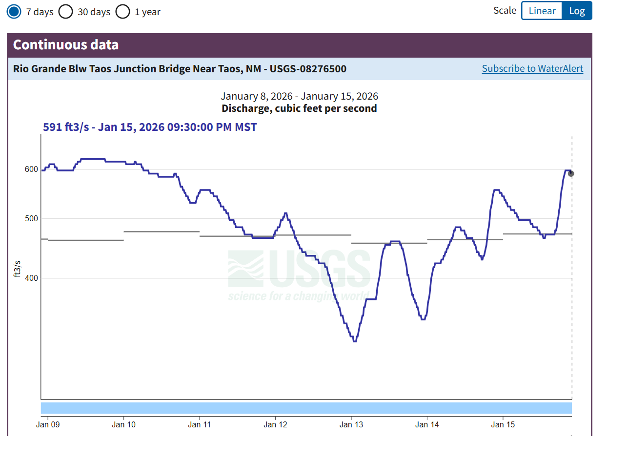
Graph of flow of the Rio Grande reported by the Below Taos Junction Bridge gauge: https://waterdata.usgs.gov/monitoring-location/USGS-08276500/#period=P7D&dataTypeId=continuous-00060-0&showMedian=true&showFieldMeasurements=true