Thank you Julia Fernandez de Maez for sharing your video!
Rafters hitting Souse Hole’s massive wave! Thank you Julia Fernandez Maez for sharing your video!

Thank you Julia Fernandez de Maez for sharing your video!
Rafters hitting Souse Hole’s massive wave! Thank you Julia Fernandez Maez for sharing your video!
The Below Taos Junction Bridge gauge is reporting 5,030 cfs, having just dropped from 5,100 cfs. To put that into perspective, today the Colorado River of the Grand Canyon has reported flows at Lees Ferry of 4,920 cfs - 7,970 cfs:
Below Taos Junction Bridge Gauge (TJB): Rio Grande Blw Taos Junction Bridge Near Taos, NM - USGS Water Data for the Nation
Colorado Rive at Lee’s Ferry: Colorado River at Lees Ferry, AZ - USGS Water Data for the Nation
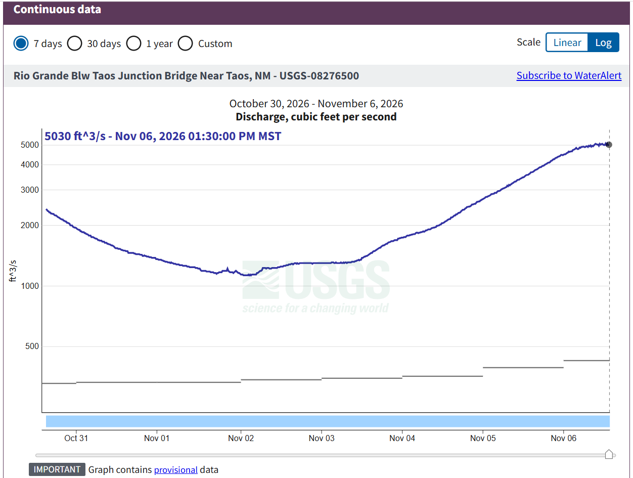
Graph of reported flows at the Below Taos Junction Bridge gauge (TJB) with a reported flow of 5,030 cfs: Rio Grande Blw Taos Junction Bridge Near Taos, NM - USGS Water Data for the Nation
When was the last time TJB got this close to 5,000 cfs?!
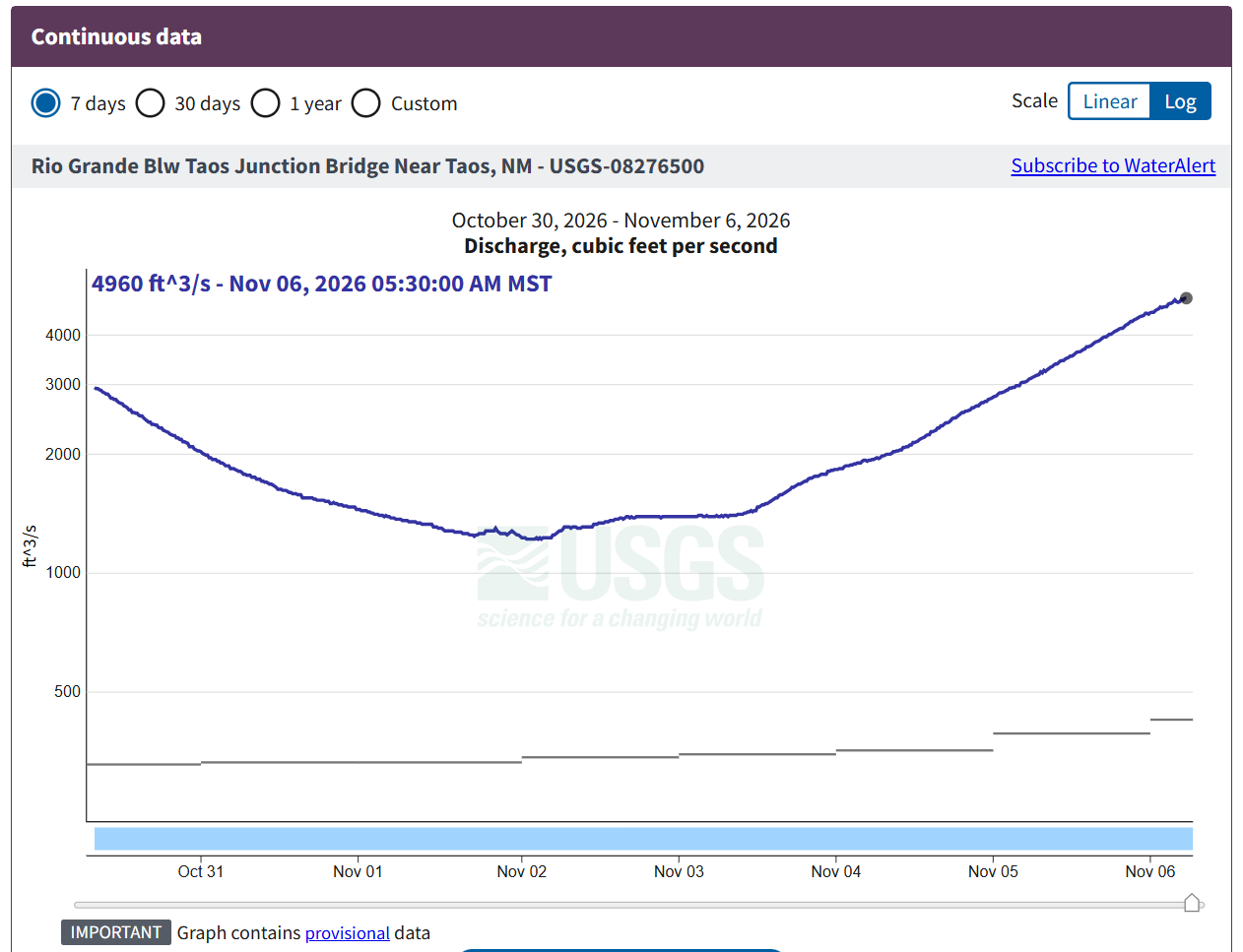
Graph of flows reported by Below Taos Junction Bridge gauge (TJB), with current flow reported as 4,960 cfs (higher than peak flow from 2023).: Rio Grande Blw Taos Junction Bridge Near Taos, NM - USGS Water Data for the Nation
Just a heads up - in 2023 the highest flow reported by TJB was 4,840 cfs. Currently the gauge is reporting 4,370 cfs, and Lobatos hasn't peaked yet (though it looks close to peaking). Right now 470 cfs separates TJB's current reported flow and the peak for 2023:
Peak flow for 2023: https://waterdata.usgs.gov/monitoring-location/USGS-08276500/#dataTypeId=continuous-00060-0&showMedian=true&showFieldMeasurements=true&startDT=2023-05-09&endDT=2023-07-01
Current flow for TJB: https://waterdata.usgs.gov/monitoring-location/USGS-08276500/#period=P7D&dataTypeId=continuous-00060-0&showMedian=true&showFieldMeasurements=true
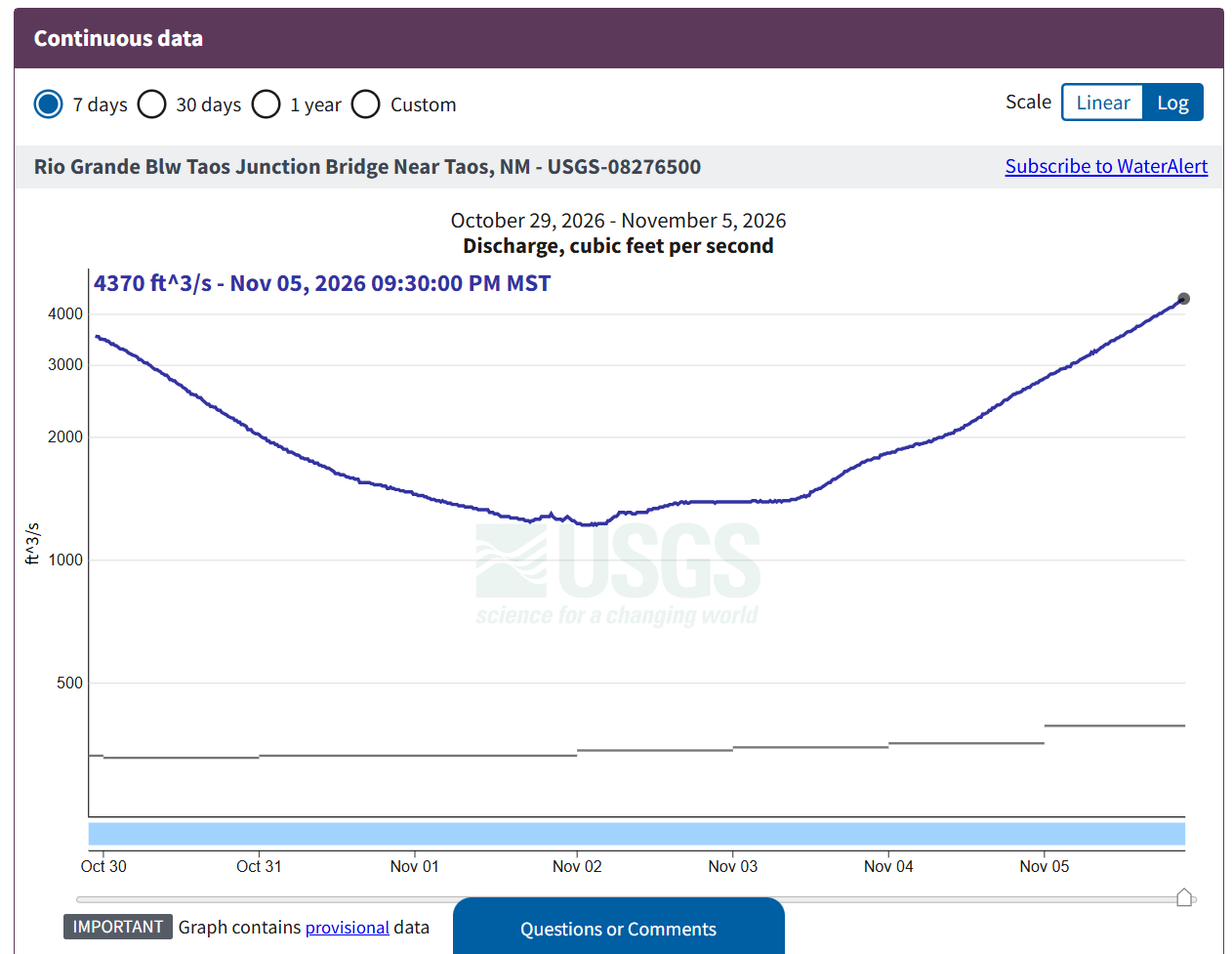
Graph of flows reported by the Below Taos Junction Bridge gauge (TJB) with current reported flow as 4,370 cfs: Rio Grande Blw Taos Junction Bridge Near Taos, NM - USGS Water Data for the Nation
Lobatos is almost at 4,000 cfs, or 400 cfs higher than last week's peak!
https://dwr.state.co.us/Tools/Stations/RIOLOBCO?params=DISCHRG
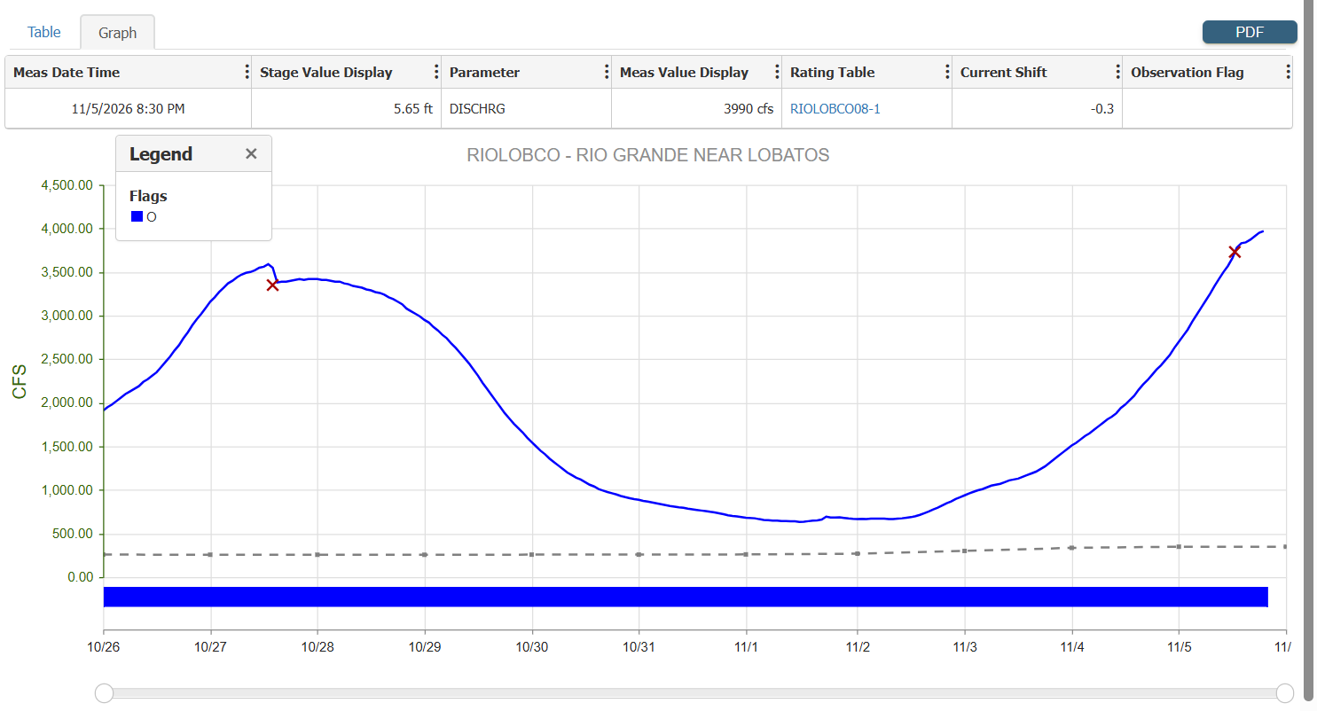
Graph showing flows reports at the Lobatos gauge in Colorado, with a current reported flow of 3,990 cfs: https://dwr.state.co.us/Tools/Stations/RIOLOBCO?params=DISCHRG
“Rivers like this are exciting, scary and unknown,” Newman said. “Whitewater is ephemeral, that’s why we keep chasing it. A lot of people see happiness as a whole – family, job, house, money – but I see whitewater as these super, super happy moments, and then I move on to the next thing.” … “My why is always changing. Whitewater pulls you toward a river, but what you remember is the people you were with, not the whitewater.”
Wow, this is from 3 days ago in Arizona - 4 inches of rain in a few hours per the report:
Here are flows for 11/5/26! The big news is the Racecourse is class IV again! The reported flow at TJB is 3,100 cfs (and this should be rising, with Lobatos reporting 3,090 cfs and rising). Just like last week, we're seeing two big river flows peaks from the Rio Grande and the Conejos come together: Conejos (near Mogote) with a reported peak of 3,830 cfs on Monday, and the Del Norte Gauge (CO) on the Rio Grande reporting a peak of 10,900 cfs also on Monday.
Here are flows for 10/30/26! Flows are dropping fast: yesterday Lobatos was dropping about around 48 cfs per hour, or about 1,152 cfs per day. In past years, the first week of November has been a time when the irrigation has stopped; and with rain in the forecast on Sunday for the Taos area, and Del Norte still reporting over 2,000 cfs, perhaps these three events will help keep water in the river (compared to pre-surge flows). In fact, the Del Norte gauge has been reporting over 1,000 cfs for more than the past 10 days.
Snow has been accumulating - current, early SNOTEL data looks good:
2027 Season: 1.7 inches
2019 (High water year): 0.9 inches
Median (1991 - 2020): 0.3 inches
2026 (Low water year): 0.1 inches
2015 (Box raft runnable into August): 0.0 inches
https://www.wcc.nrcs.usda.gov/ftpref/support/states/CO/products/#state=co&element=wteq
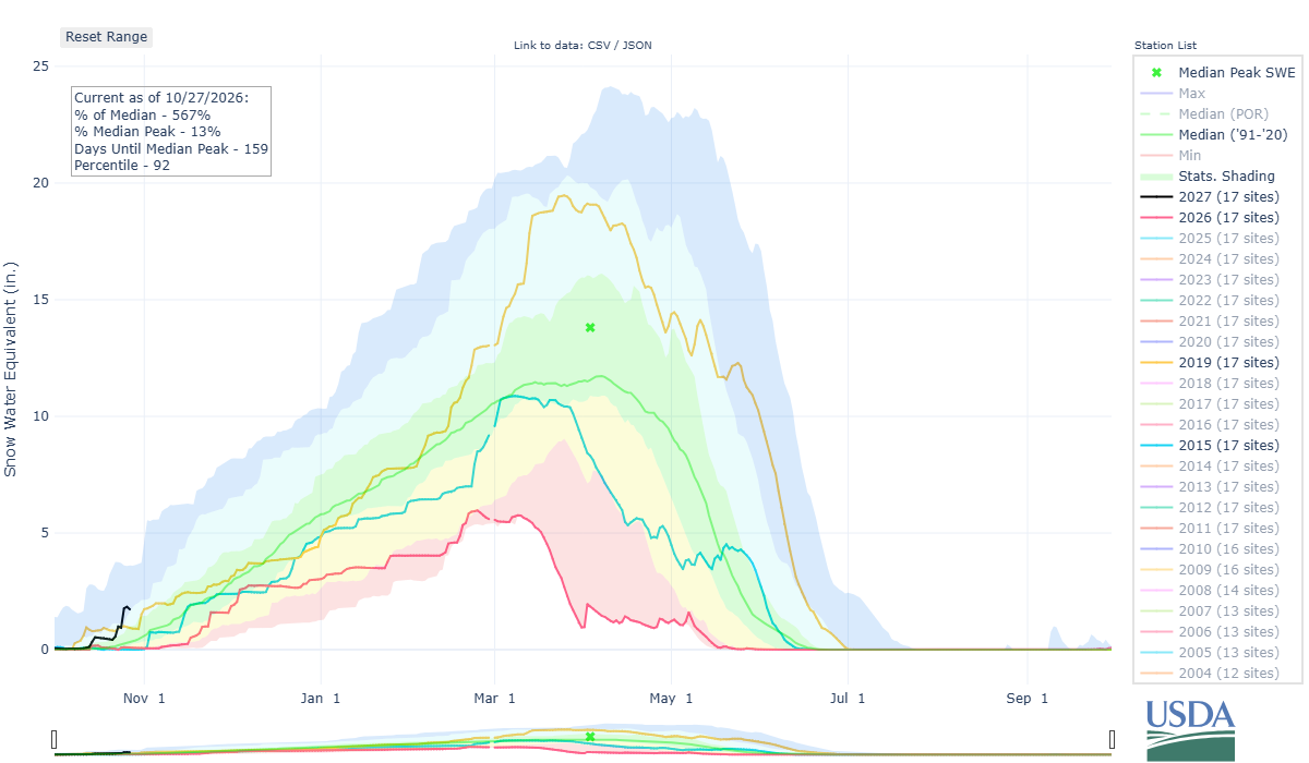
SNOTEL times series for the Upper Rio Grande: 2027 is 1.7 inches, high water year 2019 is 0.9 inches, median is 0.3 inches, low water 2026 is 0.1 inches, and 2015 (when the Box was raft runnable into August) was 0.0 inches: Colorado Snow Survey Products
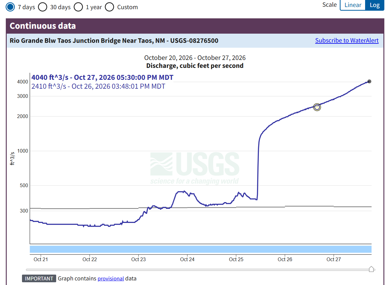
Graph of flows reported by the Below Taos Junction Bridge gauge (TJB). Current reported flow is 4,040 cfs: Rio Grande Blw Taos Junction Bridge Near Taos, NM - USGS Water Data for the Nation
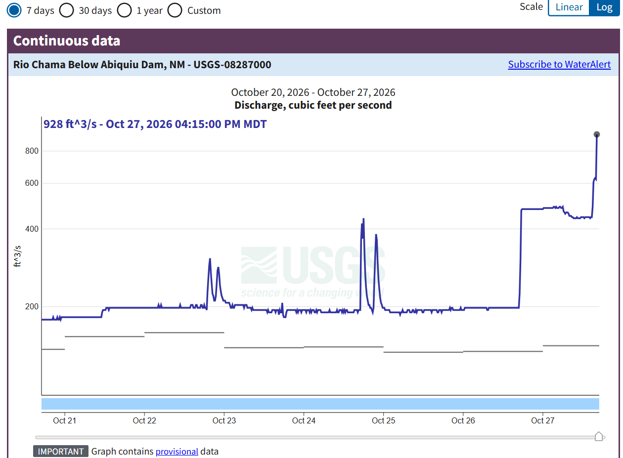
Graph of reported flows from the Below Abiquiu Dam gauge, the gauge for the Abiquiu Wave: Rio Chama Below Abiquiu Dam, NM - USGS Water Data for the Nation
Thanks again to local river guide Elias Griego for a beautiful image of the Box put in at John Dunn Bridge, with the Rio Grande flowing under during these recent high flows.
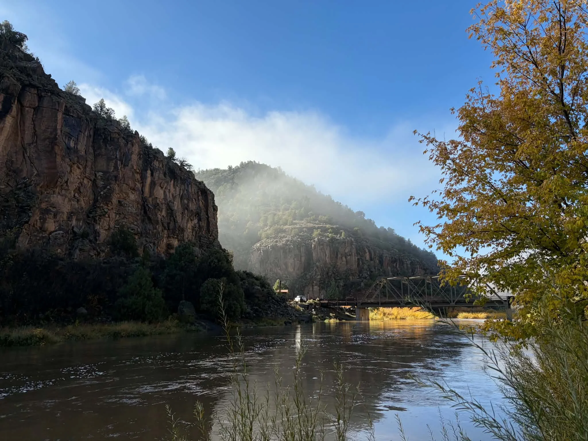
The Rio Grande flowing under John Dunn Bridge at the put in for the Box section (image by Elias Griego).
A huge thank you to Elias Griego, local river guide on the Rio Grande, for this great picture of Big Rocks rapid during the recent high flows!
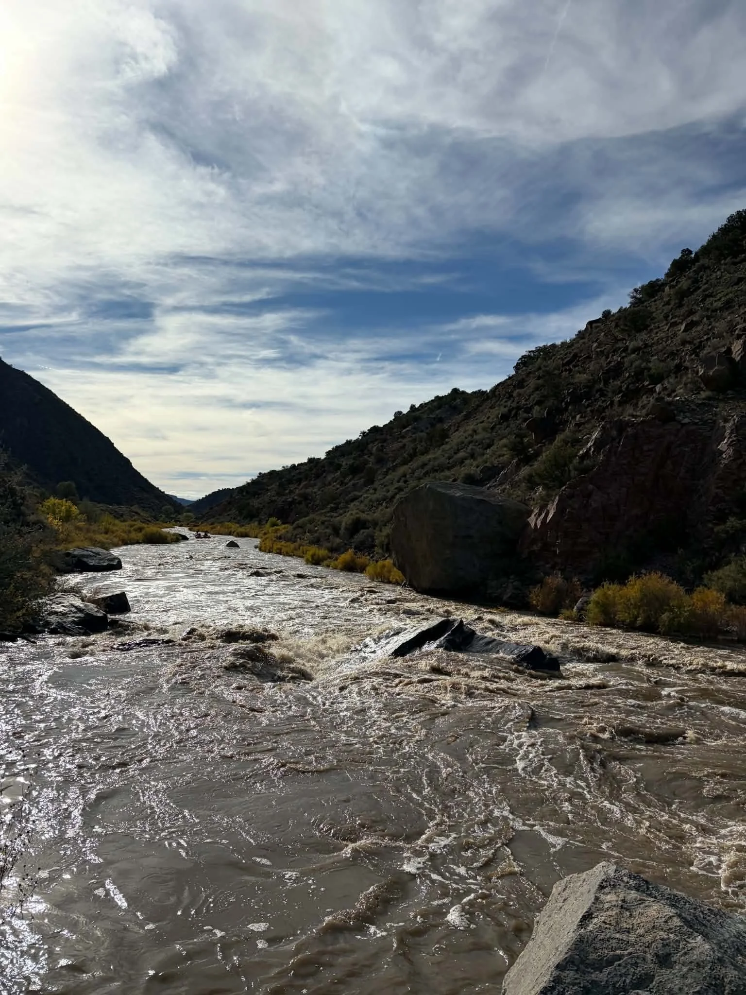
Bigs Rocks rapid during the recent highwater flows (image by Elias Griego).
Flows are up! Even the gauge for the Abiquiu Wave is reporting 607 cfs! Down in Albuquerque, reported flows are over 1,000 cfs. And down on the Racecourse, the reported flow for TJB is 3,930 cfs!
Be careful out there - Racecourse is considered class IV starting at 3,000 cfs with Mile Long Rapid running from the top of Saddle Rock through the end of Final Drop (at the bottom of the Narrows section).
More water on the way: Lobatos is reporting 3,500 cfs! Just FYI, Racecourse is considered class IV starting at 3,000 cfs!
https://dwr.state.co.us/Tools/Stations/RIOLOBCO?params=DISCHRG
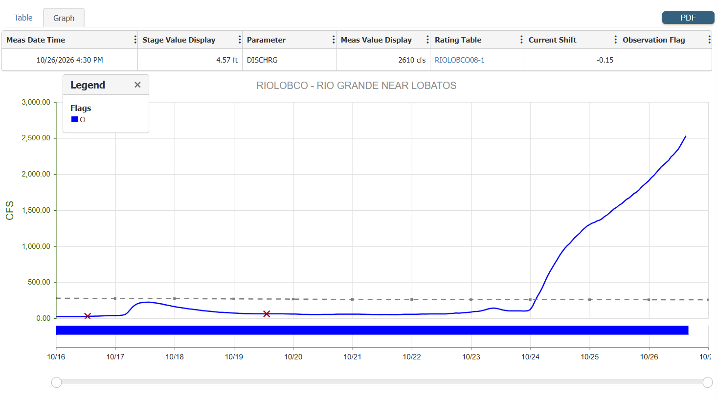
Graph of reported flows from the Lobatos gauge near the Colorado, New Mexico border. Current reported flow is 3,500 cfs: https://dwr.state.co.us/Tools/Stations/RIOLOBCO?params=DISCHRG
Abiquiu Wave is up to 477 cfs! No sure yet if this is a spike or will be a consistent flow for a bit...
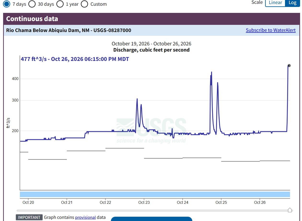
Graph of the Rio Chama below Abiquiu Dam (gauge used for the Abiquiu Wave - current reported flow is 477 cfs: Rio Chama Below Abiquiu Dam, NM - USGS Water Data for the Nation
Lobatos is reporting a flow over 2,600 cfs ... and rising!
https://dwr.state.co.us/Tools/Stations/RIOLOBCO?params=DISCHRG
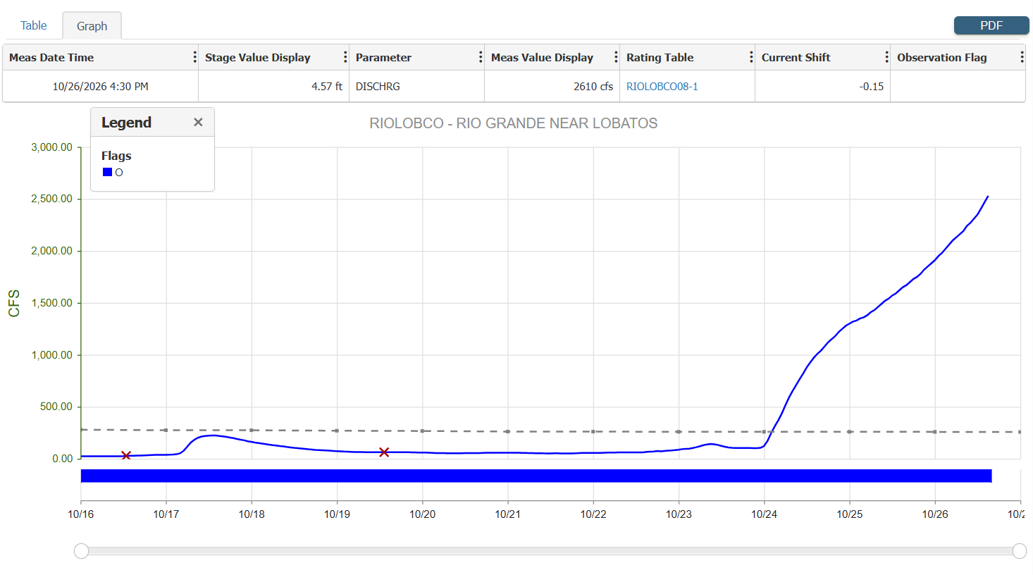
Graph showing the reported flow for the Lobatos gauge near the CO-NM border. Current reported flow is 2,610 cfs: https://dwr.state.co.us/Tools/Stations/RIOLOBCO?params=DISCHRG
Thank you Julia Fernandez De Maez for the heads up about these flows! Gauges are UP across New Mexico! Cerro gauge on the Rio Grande (Razorblade, Upper Taos Box) suddenly started rising around 9 pm last night, and now reporting 1,350 cfs and TJB (OV, Racecourse) is reporting 1,410 cfs!
The Rio Chama is still roaring above Abiquiu Reservoir, with the La Puente gauge (Mama Chama) reporting 3,490 cfs and the Day Section gauge reporting 5,750 cfs.
Just FYI, TJB is reporting the flow for the Racecourse/OV is 343 cfs.
If you go out there, it might be a good idea to be prepared for suddenly river flow surges from flash-flooding tributaries, with all the gauges going off in nearby CO (and rain predicted for Taos today and some tomorrow). Thunderstorms (lightning) also predicted:
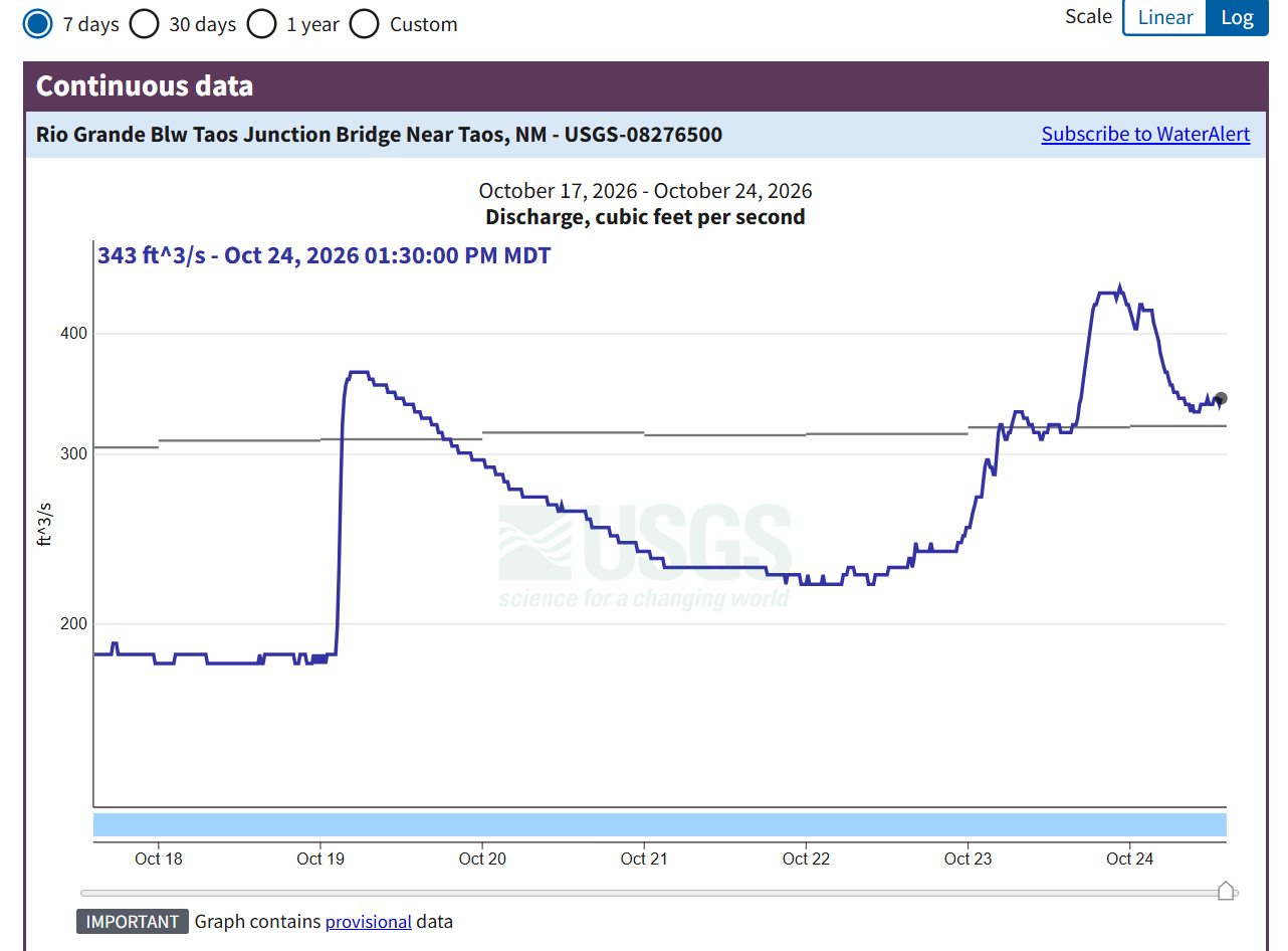
Graph of reported flow at TJB (Below Taos Junction Bridge gauge). Current reported flow is 343 cfs: Rio Grande Blw Taos Junction Bridge Near Taos, NM - USGS Water Data for the Nation