
Here are flows for 12/4/2025! And the BIG NEWS is the Rio Chama! Flow out of El Vado is 700 cfs, with the gauge above Abiquiu Reservoir reporting 686 cfs…and the flow for the Abiquiu Wave reported at 1,400 cfs! The Rio Grande is still looking good with an estimate flow for the Box of 650 cfs, and TJB reporting a flow for the Orilla Verde and Racecourse of 667 cfs. Up north in Colorado, the Wellsville gauge for the Arkansas and Royal Gorge is reporting 311 cfs (no idea about ice/snow situation), while on the Upper Colorado the gauge for Gore/Pumphouse is reporting 411 cfs; downstream from there the gauge for Barrel Springs/Shoshone is reporting 703 cfs (no idea for ice/snow along the Colorado either). And out west in Utah in the Cataract Canyon of the Colorado, the gauge at Gypsum Canyon (near Hite) is reporting 4,160 cfs.
Rio Grande
*Rio Grande near Del Norte: NA https://dwr.state.co.us/Tools/Stations/RIODELCO?params=DISCHRG
*Ute Mountain (Lobatos Gauge): 396 cfs, https://dwr.state.co.us/Tools/Stations/RIOLOBCO?params=DISCHRG
*Razorblade (Cerro Gauge): 449 cfs, https://waterdata.usgs.gov/monitoring-location/08263500/#parameterCode=00060&period=P7D
*Upper Taos Box (Cerro Gauge): 449 cfs, https://waterdata.usgs.gov/monitoring-location/08263500/#parameterCode=00060&period=P7D
*Middle Taos Box (Cerro Gauge + Red River Gauge below Fish Hatchery, NM): 483 cfs, https://waterdata.usgs.gov/monitoring-location/08263500/#parameterCode=00060&period=P7D and https://waterdata.usgs.gov/monitoring-location/08266820/#parameterCode=00060&period=P7D
*Lower Taos Box (Taos Junction Bridge, NM): 650 cfs, https://waterdata.usgs.gov/monitoring-location/08276500/#parameterCode=00060&period=P7D and https://waterdata.usgs.gov/monitoring-location/08276300/#parameterCode=00060&period=P7D
*Orilla Verde (Taos Junction Bridge, NM): 667 cfs, https://waterdata.usgs.gov/monitoring-location/08276500/#parameterCode=00060&period=P7D
*Racecourse (Taos Junction Bridge, NM): 667 cfs, https://waterdata.usgs.gov/monitoring-location/08276500/#parameterCode=00060&period=P7D
*White Rock Canyon (Otowi Bridge, NM): 1,800 cfs, https://waterdata.usgs.gov/monitoring-location/08313000/#parameterCode=00060&period=P7D
Rio Chama
*Rio Chama (La Puente Gauge): 54 cfs, https://waterdata.usgs.gov/monitoring-location/08284100/#parameterCode=00060&period=P7D
*Rio Chama (below El Vado Gauge): 700 cfs, https://waterdata.usgs.gov/monitoring-location/08285500/#parameterCode=00060&period=P7D
*Rio Chama (above Abiquiu Reservoir): 686 cfs, https://waterdata.usgs.gov/monitoring-location/08286500/#parameterCode=00060&period=P7D
*Rio Chama (below Abiquiu Dam): 1,400 cfs, https://waterdata.usgs.gov/monitoring-location/08287000/#parameterCode=00060&period=P7D
Red River
*Below Fish Hatchery near Questa, NM: 34 cfs, https://waterdata.usgs.gov/monitoring-location/08266820/#parameterCode=00060&period=P7D
Rio Pueblo de Taos
*Below Los Cordovas, NM: 16 cfs, https://waterdata.usgs.gov/monitoring-location/08276300/#parameterCode=00060&period=P7D
Jemez
*Near Jemez, NM: 16 cfs, https://waterdata.usgs.gov/monitoring-location/08324000/#parameterCode=00060&period=P7D
Canadian River
*Near Taylor Springs, NM: 9 cfs [note: gauge reading had been off in the summer] https://waterdata.usgs.gov/monitoring-location/07211500/#parameterCode=00060&period=P7D
Pecos River
*Near Pecos, NM: 49 cfs, https://waterdata.usgs.gov/monitoring-location/08378500/#parameterCode=00060&period=P7D
*Near Anton Chico, NM: 26 cfs, https://waterdata.usgs.gov/monitoring-location/08379500/#parameterCode=00060&period=P7D
*Below Brantley Dam near Carlsbad, NM: 21 cfs, https://waterdata.usgs.gov/monitoring-location/08401500/#parameterCode=00060&period=P7D
Gila River
Near Gila Hot Springs, NM: 52 cfs, https://waterdata.usgs.gov/monitoring-location/09430030/#parameterCode=00060&period=P7D
Near Gila, NM: 109 cfs, https://waterdata.usgs.gov/monitoring-location/09430500/#parameterCode=00060&period=P7D
Near Redrock, NM: 73 cfs, https://waterdata.usgs.gov/monitoring-location/09431500/#parameterCode=00060&period=P7D
San Francisco River
At Reserve, NM: 2 cfs, https://waterdata.usgs.gov/monitoring-location/09442681/#parameterCode=00060&period=P7D
Near Glenwood, NM: 26 cfs, https://waterdata.usgs.gov/monitoring-location/09444000/#parameterCode=00060&period=P7D
Arkansas River
*Pine Creek/Numbers/Fractions, CO: At Granite Gauge: NA, https://dwr.state.co.us/Tools/Stations/ARKGRNCO?params=DISCHRG; Below Granite Gauge, main Pine ------*Creek/Numbers/Fractions gauge: NA, https://waterdata.usgs.gov/monitoring-location/07087050/#dataTypeId=continuous-00060-0&period=P7D
*Browns Canyon (near Nathrop Gauge, CO): NA, https://waterdata.usgs.gov/monitoring-location/07091200/#dataTypeId=continuous-00060-0&period=P7D&showMedian=false
*At Salida, CO: NA, https://dwr.state.co.us/Tools/Stations/ARKSALCO?params=DISCHRG
*Royal Gorge (Wellsville Gauge, CO): 311 cfs, https://www.dwr.state.co.us/Tools/Stations/ARKWELCO?params=DISCHRG
San Juan River
*At Pagosa Springs, CO: NA, https://waterdata.usgs.gov/monitoring-location/09342500/#dataTypeId=continuous-00060-0&period=P7D&showMedian=false
*At Farmington, NM: 635 cfs, https://waterdata.usgs.gov/monitoring-location/09365000/#parameterCode=00060&period=P7D
Piedra River
*Near Arboles, CO: NA, https://waterdata.usgs.gov/monitoring-location/09349800/#dataTypeId=continuous-00060-0&period=P7D&showMedian=false
Animas River
*Below Silverton, CO: 34 cfs, https://waterdata.usgs.gov/monitoring-location/09358000/#dataTypeId=continuous-00060-0&period=P7D&showMedian=false
*At Tall Timber Resort above Tacoma, CO: NA, https://waterdata.usgs.gov/monitoring-location/09359500/#parameterCode=00060&period=P7D
*At Durango, CO: 222 cfs, https://waterdata.usgs.gov/monitoring-location/09361500/#dataTypeId=continuous-00060-0&period=P7D&showMedian=false
*Below Aztec, NM: 333 cfs, https://waterdata.usgs.gov/monitoring-location/09364010/#parameterCode=00060&period=P7D
Gauges Pages:
American Whitewater - Arizona: https://www.americanwhitewater.org/.../state.../state/AZ/
American Whitewater - Colorado: https://www.americanwhitewater.org/.../state.../state/CO/
American Whitewater - Texas: https://www.americanwhitewater.org/.../state.../state/TX/
American Whitewater - Utah: https://www.americanwhitewater.org/.../state.../state/UT/
Stations - Current Conditions - Colorado Department of Natural Resources: https://dwr.state.co.us/tools/stations
USGS Current Conditions for New Mexico: Streamflow: https://waterdata.usgs.gov/nm/nwis/current/?type=flow...
USGS Current Conditions for USGS 07087050 ARKANSAS RIVER BELOW GRANITE, CO: https://waterdata.usgs.gov/usa/nwis/uv?07087050
USGS Current Conditions for USGS 08447300 Pecos Rv at Brotherton Rh nr Pandale, TX: https://waterdata.usgs.gov/nwis/uv?site_no=08447300
USGS Current Conditions for USGS 09380000 COLORADO RIVER AT LEES FERRY, AZ: https://waterdata.usgs.gov/az/nwis/uv?site_no=09380000
More reported regional flows…
Rio Grande (Box Canyon near Creede, CO): 2 cfs
Rio Grande (Wagon Wheel Gap, CO): 124 cfs
Rio Grande (Hoodoos Section of Big Bend, TX): 15 cfs
Rio Grande (Mariscal Section of Big Bend, TX): 36 cfs
Pecos River (near Pandale, TX): 50 cfs
Cache La Poudre (at Canyon Mouth near Fort Collins, CO): NA (more accurate flows can be found at Poudre Rock Report: http://www.poudrerockreport.com/ and https://www.facebook.com/rockreport)
Clear Creek (near Lawson, CO): 23 cfs
Clear Creek (at Golden, CO): 31 cfs
Colorado River (Gore Canyon, CO): 411 cfs
Colorado River (Pumphouse Section, CO): 411 cfs
Colorado River (Shoshone Section, CO): 740 cfs
Colorado River (Westwater Canyon, UT): 2,240 cfs
Colorado River (Cataract Canyon, UT): 4,180 cfs Colorado River (Cataract Canyon, UT): 4,180 cfs [Note: gauge at Gypsum Canyon near Hite, UT]
Colorado River (Grand Canyon, AZ): about 6,150 cfs - about 10,300 cfs
Green River (near Greendale, UT): 847 cfs
Green River (near Jensen, UT): 1,140 cfs
Conejos River (below Platoro Reservoir, CO): 32 cfs
Dolores River (below McPhee Reservoir, CO): 15 cfs
Gunnison River (Black Canyon, CO): 352 cfs
Gunnison River (Gunnison Gorge, CO): 352 cfs
San Miguel River (near Placerville, CO): 56 cfs
North Fork South Platte (Bailey Canyon, CO): NA
North Fork South Platte (Foxton Run, CO): NA
South Platte (Chutes Run below Deckers, CO): 121 cfs [Note: gauge data from secondary sources, gauge page says reliability is unknown.]
South Platte (Waterton Canyon, CO): 243 cfs
Yampa River (at Steamboat Springs, CO): 75 cfs
Yampa River (above Elkhead Creek near Hayden, CO): NA
Salt River (Day Section below U.S. 60 Bridge, AZ): 170 cfs
Salt River (Wilderness Section, AZ): 170 cfs
Verde River (below Tangle Creek above Horseshoe Dam, AZ): 364 cfs
Guadalupe River (above Comal River at New Braunfels, TX): 95 cfs
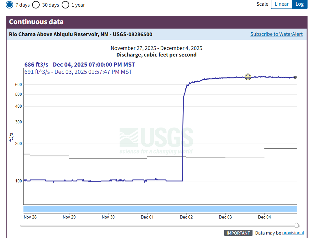
Flow reported from gauge above Abiquiu Reservoir on the Rio Chama (Rio Chama Above Abiquiu Reservoir, NM - USGS Water Data for the Nation).