
by Rock Snot
Here are flows for 11/28/2025! There's been a roughly 60 cfs drop at Lobatos, but flows are still looking good on the Rio for some winter boating: the Taos has a possible estimated flow of 715 cfs (so far), and the Orilla Verde and Racecourse have reported flows of 725 cfs. Up north in Colorado, the Royal Gorge has a reported flow of 367 cfs (though, no idea yet if there are ice bridges/dams on the river in the Gorge). Out on the Upper Colorado, the reported flow for Gorge Canyon and the Pumphouse sections is 438 cfs, while downstream at Barrel Springs and Shoshone, the reported flow is 732 cfs. While out in Cataract Canyon of the Colorado River in Utah, the reported flow at Gypsum Canyon (near Hite) is not reporting at the time of this post. [UPDATE: USGS website reported 4,200 cfs for Cataract Canyon at Gypsum Canyon near Hite, UT just after this post was made.]
WARNING: when weather is cold enough to allow ice to form in rivers, these rivers can develop ice "bridges" or places where a layer of ice (sometimes thick) is formed across the river. Just because there is a flow doesn't mean there aren't significant (and dangerous) ice obstructions in the river.
NOTE: gauge readings can be distorted when ice is forming in rivers
Rio Grande
Rio Grande near Del Norte: 296 cfs, https://dwr.state.co.us/Tools/Stations/RIODELCO?params=DISCHRG
Ute Mountain (Lobatos Gauge): 424 cfs, https://dwr.state.co.us/Tools/Stations/RIOLOBCO?params=DISCHRG
Razorblade (Cerro Gauge): 509 cfs, https://waterdata.usgs.gov/monitoring-location/08263500/#parameterCode=00060&period=P7D
Upper Taos Box (Cerro Gauge): 509 cfs, https://waterdata.usgs.gov/monitoring-location/08263500/#parameterCode=00060&period=P7D
Middle Taos Box (Cerro Gauge + Red River Gauge below Fish Hatchery, NM): 554 cfs, https://waterdata.usgs.gov/monitoring-location/08263500/#parameterCode=00060&period=P7D and https://waterdata.usgs.gov/monitoring-location/08266820/#parameterCode=00060&period=P7D [Note: individual flow page for Red River wasn’t working at time of post]
Lower Taos Box (Taos Junction Bridge, NM): an estimate is 715 cfs, https://waterdata.usgs.gov/monitoring-location/08276500/#parameterCode=00060&period=P7D and https://waterdata.usgs.gov/monitoring-location/08276300/#parameterCode=00060&period=P7D
Orilla Verde (Taos Junction Bridge, NM): 725 cfs, https://waterdata.usgs.gov/monitoring-location/08276500/#parameterCode=00060&period=P7D
Racecourse (Taos Junction Bridge, NM): 725 cfs, https://waterdata.usgs.gov/monitoring-location/08276500/#parameterCode=00060&period=P7D
White Rock Canyon (Otowi Bridge, NM): 912 cfs, https://waterdata.usgs.gov/monitoring-location/08313000/#parameterCode=00060&period=P7D
Rio Chama
Rio Chama (La Puente Gauge): 59 cfs, https://waterdata.usgs.gov/monitoring-location/08284100/#parameterCode=00060&period=P7D
Rio Chama (below El Vado Gauge): 99 cfs, https://waterdata.usgs.gov/monitoring-location/08285500/#parameterCode=00060&period=P7D
Rio Chama (above Abiquiu Reservoir): 100 cfs, https://waterdata.usgs.gov/monitoring-location/08286500/#parameterCode=00060&period=P7D
Rio Chama (below Abiquiu Dam): 123 cfs, https://waterdata.usgs.gov/monitoring-location/08287000/#parameterCode=00060&period=P7D
Red River
Below Fish Hatchery near Questa, NM: 45 cfs, https://waterdata.usgs.gov/monitoring-location/08266820/#parameterCode=00060&period=P7D [Note: individual flow page for Red River wasn’t working at time of post]
Rio Pueblo de Taos
Below Los Cordovas, NM: 9 cfs, https://waterdata.usgs.gov/monitoring-location/08276300/#parameterCode=00060&period=P7D
Jemez
Near Jemez, NM: 18 cfs, https://waterdata.usgs.gov/monitoring-location/08324000/#parameterCode=00060&period=P7D
Canadian River
Near Taylor Springs, NM: 8 cfs [Note: flow report was observed as inaccurate last summer], https://waterdata.usgs.gov/monitoring-location/07211500/#parameterCode=00060&period=P7D
Pecos River
Near Pecos, NM: 37 cfs, https://waterdata.usgs.gov/monitoring-location/08378500/#parameterCode=00060&period=P7D
Near Anton Chico, NM: 1 cfs, https://waterdata.usgs.gov/monitoring-location/08379500/#parameterCode=00060&period=P7D
Below Brantley Dam near Carlsbad, NM: 21 cfs, https://waterdata.usgs.gov/monitoring-location/08401500/#parameterCode=00060&period=P7D
Gila River
Near Gila Hot Springs, NM: 39 cfs, https://waterdata.usgs.gov/monitoring-location/09430030/#parameterCode=00060&period=P7D
Near Gila, NM: 135 cfs, https://waterdata.usgs.gov/monitoring-location/09430500/#parameterCode=00060&period=P7D
Near Redrock, NM: 85 cfs, https://waterdata.usgs.gov/monitoring-location/09431500/#parameterCode=00060&period=P7D
San Francisco River
At Reserve, NM: 2 cfs, https://waterdata.usgs.gov/monitoring-location/09442681/#parameterCode=00060&period=P7D
Near Glenwood, NM: 29 cfs, https://waterdata.usgs.gov/monitoring-location/09444000/#parameterCode=00060&period=P7D
Arkansas River
Pine Creek/Numbers/Fractions, CO: At Granite Gauge: 76 cfs, https://dwr.state.co.us/Tools/Stations/ARKGRNCO?params=DISCHRG; Below Granite Gauge, main Pine Creek/Numbers/Fractions gauge: NA, https://waterdata.usgs.gov/monitoring-location/07087050/#dataTypeId=continuous-00060-0&period=P7D
Browns Canyon (near Nathrop Gauge, CO): NA, https://waterdata.usgs.gov/monitoring-location/07091200/#dataTypeId=continuous-00060-0&period=P7D&showMedian=false
At Salida, CO: 258 cfs, https://dwr.state.co.us/Tools/Stations/ARKSALCO?params=DISCHRG
Royal Gorge (Wellsville Gauge, CO): 367 cfs, https://www.dwr.state.co.us/Tools/Stations/ARKWELCO?params=DISCHRG
San Juan River
At Pagosa Springs, CO: NA, https://waterdata.usgs.gov/monitoring-location/09342500/#dataTypeId=continuous-00060-0&period=P7D&showMedian=false
At Farmington, NM: 688 cfs, https://waterdata.usgs.gov/monitoring-location/09365000/#parameterCode=00060&period=P7D
Piedra River
Near Arboles, CO: NA, https://waterdata.usgs.gov/monitoring-location/09349800/#dataTypeId=continuous-00060-0&period=P7D&showMedian=false
Animas River
Below Silverton, CO: 34 cfs, https://waterdata.usgs.gov/monitoring-location/09358000/#dataTypeId=continuous-00060-0&period=P7D&showMedian=false
At Tall Timber Resort above Tacoma, CO: 160 cfs, https://waterdata.usgs.gov/monitoring-location/09359500/#parameterCode=00060&period=P7D
At Durango, CO: 236 cfs, https://waterdata.usgs.gov/monitoring-location/09361500/#dataTypeId=continuous-00060-0&period=P7D&showMedian=false
Below Aztec, NM: 337 cfs, https://waterdata.usgs.gov/monitoring-location/09364010/#parameterCode=00060&period=P7D
Gauges Pages:
American Whitewater - Arizona: https://www.americanwhitewater.org/.../state.../state/AZ/
American Whitewater - Colorado: https://www.americanwhitewater.org/.../state.../state/CO/
American Whitewater - Texas: https://www.americanwhitewater.org/.../state.../state/TX/
American Whitewater - Utah: https://www.americanwhitewater.org/.../state.../state/UT/
Stations - Current Conditions - Colorado Department of Natural Resources: https://dwr.state.co.us/tools/stations
USGS Current Conditions for New Mexico: Streamflow: https://waterdata.usgs.gov/nm/nwis/current/?type=flow...
USGS Current Conditions for USGS 07087050 ARKANSAS RIVER BELOW GRANITE, CO: https://waterdata.usgs.gov/usa/nwis/uv?07087050
USGS Current Conditions for USGS 08447300 Pecos Rv at Brotherton Rh nr Pandale, TX: https://waterdata.usgs.gov/nwis/uv?site_no=08447300
USGS Current Conditions for USGS 09380000 COLORADO RIVER AT LEES FERRY, AZ: https://waterdata.usgs.gov/az/nwis/uv?site_no=09380000
More Regional flows reports…
Rio Grande (Box Canyon near Creede, CO): 2 cfs
Rio Grande (Wagon Wheel Gap, CO): 160 cfs
Rio Grande (Hoodoos Section of Big Bend, TX): 11 cfs
Rio Grande (Mariscal Section of Big Bend, TX): 33 cfs
Pecos River (near Pandale, TX): 49 cfs
Cache La Poudre (at Canyon Mouth near Fort Collins, CO): 62 cfs (more accurate flows can be found at Poudre Rock Report: http://www.poudrerockreport.com/ and https://www.facebook.com/rockreport)
Clear Creek (near Lawson, CO): 22 cfs
Clear Creek (at Golden, CO): 39 cfs
Colorado River (Gore Canyon, CO): 438 cfs
Colorado River (Pumphouse Section, CO): 438 cfs
Colorado River (Shoshone Section, CO): 732 cfs
Colorado River (Westwater Canyon, UT): 2,380 cfs
Colorado River (Cataract Canyon, UT): 4,200 cfs [Note: gauge at Gypsum Canyon near Hite, UT]
Colorado River (Grand Canyon, AZ): about 6,210 cfs - about 9,850 cfs
Green River (near Greendale, UT): 847 cfs
Green River (near Jensen, UT): 1,320 cfs
Conejos River (below Platoro Reservoir, CO): 31 cfs
Dolores River (below McPhee Reservoir, CO): 15 cfs
Gunnison River (Black Canyon, CO): 361 cfs
Gunnison River (Gunnison Gorge, CO): 361 cfs
San Miguel River (near Placerville, CO): 65 cfs
North Fork South Platte (Bailey Canyon, CO): NA
North Fork South Platte (Foxton Run, CO): NA
South Platte (Chutes Run below Deckers, CO): 170 cfs [Note: gauge data from secondary sources, gauge page says reliability is unknown.]
South Platte (Waterton Canyon, CO): 292 cfs
Yampa River (at Steamboat Springs, CO): 75 cfs
Yampa River (above Elkhead Creek near Hayden, CO): 184 cfs
Salt River (Day Section below U.S. 60 Bridge, AZ): 222 cfs
Salt River (Wilderness Section, AZ): 222 cfs
Verde River (below Tangle Creek above Horseshoe Dam, AZ): 463 cfs
Guadalupe River (above Comal River at New Braunfels, TX): 120 cfs
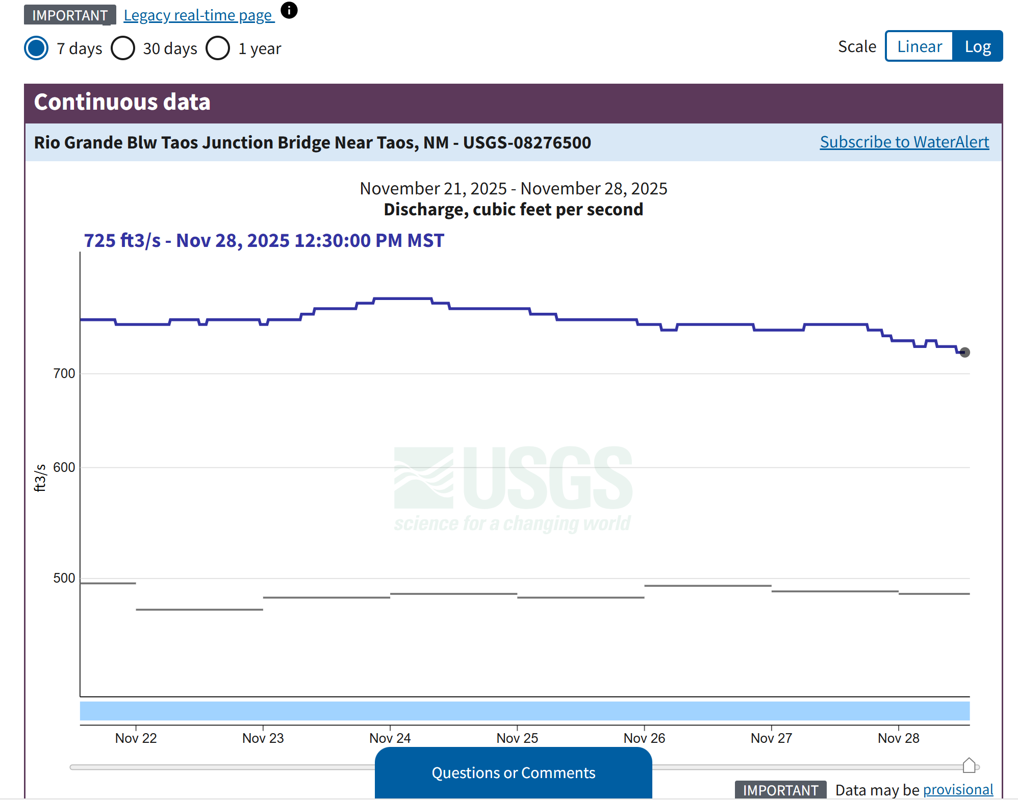
Graph of Rio Grande flow at the Below Taos Junction Bridge gauge (TJB): Rio Grande Near Cerro, NM - USGS Water Data for the Nation.