
Home
About
What We Do
Calendar
Meetings & Events
River Cleanups
Pool Sessions
Safety & Stewardship
Social Media
Contact
Advocacy
Advocacy News
Gila River
Rio Grande
Rio Chama
Four Corners Paddle Trail and Animas River
Member's Page
Trip Reports
Presentations
Library
Rental Equipment
Flip Line
Board Meetings and Bylaws
Stream Gauges
Snowpack
The Flip Line Blog
NM Stream Access
NM Stream Access Legal Action
Media Coverage
Maps
Photos and Videos
Legal Documents
Mothers Day Races
The Latest News for MD Race
Mother's Day Race
Mothers Day Race Results
Volunteer for MD Race
Register For MD Races
Join AWC

Adobe Whitewater Club

Home
About
What We Do
Calendar
Meetings & Events
River Cleanups
Pool Sessions
Safety & Stewardship
Social Media
Contact
Advocacy
Advocacy News
Gila River
Rio Grande
Rio Chama
Four Corners Paddle Trail and Animas River
Member's Page
Trip Reports
Presentations
Library
Rental Equipment
Flip Line
Board Meetings and Bylaws
Stream Gauges
Snowpack
The Flip Line Blog
NM Stream Access
NM Stream Access Legal Action
Media Coverage
Maps
Photos and Videos
Legal Documents
Mothers Day Races
The Latest News for MD Race
Mother's Day Race
Mothers Day Race Results
Volunteer for MD Race
Register For MD Races
Join AWC
Joey Coburn
October 23, 2026

Rio Chama gauges, above Abiquiu Dam, report big flows

Joey Coburn
October 23, 2026

Rio Chama is rising above Abiquiu Reservoir - La Puente gauge exceeded 10,000 cfs.

  • Mama Chama (La Puente gauge): 9,360 cfs

  • Wilderness Section (El Vado gauge): 1,900 cfs

  • Day Section (above Abiquiu Reservoir gauge): 5,950 cfs

  • Abiquiu Wave (below Abiquiu Dam gauge): 194 cfs

Gauge Pages:

  • La Puente Gauge: https://waterdata.usgs.gov/monitoring-location/USGS-08284100/#period=P7D&dataTypeId=continuous-00060-0&showMedian=true&showFieldMeasurements=true

  • El Vado Gauge: https://waterdata.usgs.gov/monitoring-location/USGS-08285500/#period=P7D&dataTypeId=continuous-00060-0&showMedian=true&showFieldMeasurements=true

  • Above Abiquiu Reservoir Gauge: https://waterdata.usgs.gov/monitoring-location/USGS-08286500/#period=P7D&dataTypeId=continuous-00060-0&showMedian=true&showFieldMeasurements=true

  • Below Abiquiu Dam Gauge: https://waterdata.usgs.gov/monitoring-location/USGS-08287000/#period=P7D&dataTypeId=continuous-00060-0&showMedian=true&showFieldMeasurements=true
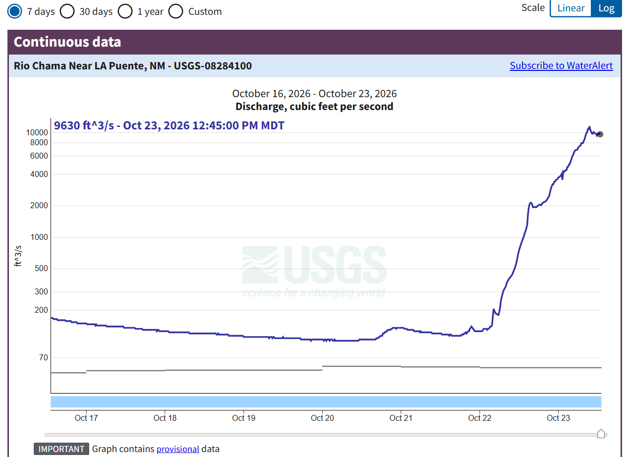
Graph of Rio Chama reported flows near La Puente, NM. Reported flow exceeded 10,000 cfs.

Graph of Rio Chama reported flows near La Puente, NM. Reported flow exceeded 10,000 cfs: Rio Chama Near LA Puente, NM - USGS Water Data for the Nation

Older PostWatchout in southern Colorado: flood waters rising!
Back to Top

Contact: board@adobewhitewater.org

For the Love of Rivers