
Flows are up! Even the gauge for the Abiquiu Wave is reporting 607 cfs! Down in Albuquerque, reported flows are over 1,000 cfs. And down on the Racecourse, the reported flow for TJB is 3,930 cfs!
Be careful out there - Racecourse is considered class IV starting at 3,000 cfs with Mile Long Rapid running from the top of Saddle Rock through the end of Final Drop (at the bottom of the Narrows section).
Rio Grande
Rio Grande near Del Norte: 3,390 cfs, https://dwr.state.co.us/Tools/Stations/RIODELCO?params=DISCHRG
Ute Mountain (Lobatos Gauge): 3,370 cfs, https://dwr.state.co.us/Tools/Stations/RIOLOBCO?params=DISCHRG
Razorblade (Cerro Gauge): 3,300 cfs, https://waterdata.usgs.gov/monitoring-location/08263500/#parameterCode=00060&period=P7D
Upper Taos Box (Cerro Gauge): 3,300 cfs, https://waterdata.usgs.gov/monitoring-location/08263500/#parameterCode=00060&period=P7D
Middle Taos Box (Cerro Gauge + Red River Gauge below Fish Hatchery, NM): an estimate of about 3,380 cfs, https://waterdata.usgs.gov/monitoring-location/08263500/#parameterCode=00060&period=P7Dandhttps://waterdata.usgs.gov/monitoring-location/08266820/#parameterCode=00060&period=P7D
Lower Taos Box (Taos Junction Bridge, NM): an estimate of 3,848 cfs, https://waterdata.usgs.gov/monitoring-location/08276500/#parameterCode=00060&period=P7Dandhttps://waterdata.usgs.gov/monitoring-location/08276300/#parameterCode=00060&period=P7D
Orilla Verde (Taos Junction Bridge, NM): 3,930 cfs, https://waterdata.usgs.gov/monitoring-location/08276500/#parameterCode=00060&period=P7D
Racecourse (Taos Junction Bridge, NM): 3,930 cfs, https://waterdata.usgs.gov/monitoring-location/08276500/#parameterCode=00060&period=P7D,
White Rock Canyon (Otowi Bridge, NM): 3,280 cfs, https://waterdata.usgs.gov/monitoring-location/08313000/#parameterCode=00060&period=P7D
Rio Grande at Alameda Bridge, NM: 1,190 cfs, https://waterdata.usgs.gov/monitoring-location/USGS-08329918/#dataTypeId=continuous-00060-0&period=P7D&showMedian=true&showFieldMeasurements=true
Red River
Below Fish Hatchery near Questa, NM: 80 cfs, https://waterdata.usgs.gov/monitoring-location/08266820/#parameterCode=00060&period=P7D
Rio Pueblo de Taos
Below Los Cordovas, NM: 81 cfs,https://waterdata.usgs.gov/monitoring-location/08276300/#parameterCode=00060&period=P7D
Rio Chama
Rio Chama (La Puente Gauge): 1,730 cfs, https://waterdata.usgs.gov/monitoring-location/08284100/#parameterCode=00060&period=P7D
Rio Chama (below El Vado Gauge): 2,000 cfs, https://waterdata.usgs.gov/monitoring-location/08285500/#parameterCode=00060&period=P7D
Rio Chama (above Abiquiu Reservoir): 2,690 cfs,https://waterdata.usgs.gov/monitoring-location/08286500/#parameterCode=00060&period=P7D
Rio Chama (below Abiquiu Dam): 607 cfs, https://waterdata.usgs.gov/monitoring-location/08287000/#parameterCode=00060&period=P7D
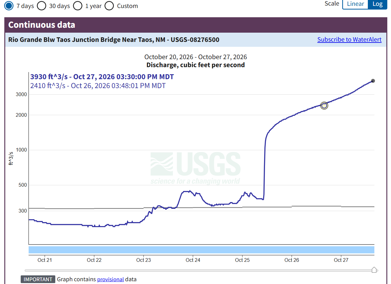
Graph of reported flows from the Below Taos Junction Bridge gauge (TJB), with current flow reported as 3,930 cfs: Rio Grande Blw Taos Junction Bridge Near Taos, NM - USGS Water Data for the Nation